
Brookhaven City Centre Master Plan
brookhaven city centre master plan
Embracing transdisciplinary collaboration, HGOR led a talented team of consultants with a shared vision of developing an informed vision for a development guide that establishes a strong framework for the future city center. The focus involves knitting together the relationship and complexities of enhanced pedestrian safety, improved vehicle circulation, sound civil engineering, and water quality strategy to form purposeful, open spaces which enhance civic needs, organize walkable urban scale blocks, and create a place of lasting character for the citizens of Brookhaven.
The HGOR team used public outreach to connect with the citizens of Brookhaven, where they listened and gathered feedback for one year. HGOR led the team through a public engagement process that utilized digital and in-person survey tools, online outreach platforms, and disseminating data and updates through a digital platform for one year to deliver a completely transparent method of keeping the community informed and updated during the master plan process.
GUIDING PRINCIPLES
Establish a Unique & Authentic Identity
Create an Inclusive Experience
Improve Connectivity
Deliver an Achievable Plan
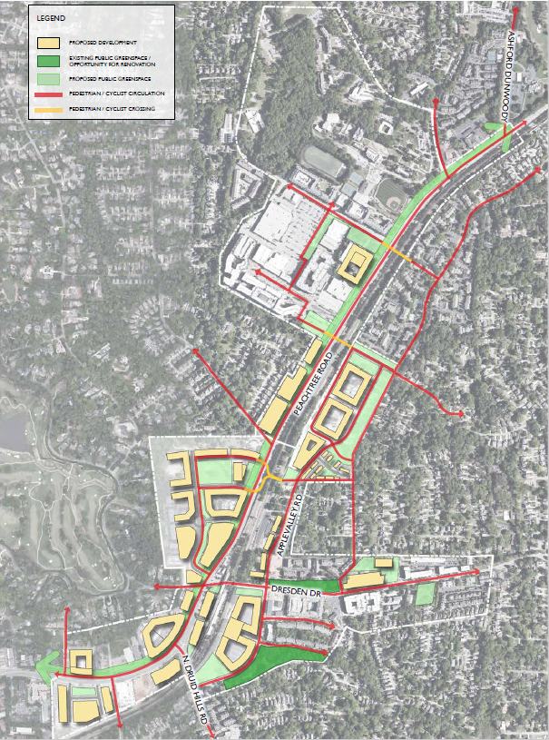
Additionally, the framework plan focuses on improving pedestrian and cyclist accessibility and safety through the corridor. Mechanisms such as a road diet and multipurpose corridor were proposed to provide safety and refuge with pedestrian scale enhancements such as cohesive landscaping, sustainable strategies, and an arts program to establish a united character and identity for the corridor.
As a multi-phased framework plan, the Brookhaven Masterplan is a guiding armature for utilizing purposeful, open space and improved connectivity as a vision for the growth of the City of Brookhaven.
PLANNING PROCESS
STUDY AREA CONDITIONS
Transportation data is from the Georgia Department of Transportation’s Traffic Analysis and Data Application (TADA) database. Information gathered analyzes the existing conditions along Peachtree Road, illustrating average daily life volumes, per roadway segment, along the corridor. Parameters such as existing roadway width, transit stops, intersection signal control, and average daily traffic volume accurately establish the scope of existing roadway conditions. Further, the data helps support future policy and design decisions regarding the number of lanes needed per corridor segment.
Annual traffic statistics were sourced from the GDOT TADA database between 2015 and 2019 to create a historical snapshot of pre-pandemic traffic levels within the Peachtree Road project corridor. The calculated growth in traffic was determined using only traffic stations located within the project corridor study area.
Section 16 below at Peachtree Road, north of the Ashford Dunwoody intersection, comprises two lanes north, two lanes south, and a center median, a total of five lines. The average daily traffic count is 41,070 cars. This section of the road supports nearly ten thousand more vehicles per day with one less through lane.


The first segment of Peachtree Road in this corridor, section 1, consists of three lanes going north and two lanes going south with a median serving as a turn lane, totaling six lanes. The 2019 average daily traffic count at this section is 33,900 cars.
Sections 6 and 7 highlight a substantial road inefficiency within the study area. Section 7 shows a southbound through lane suddenly converting into a turn lane. These conditions confuse drivers and contribute to increased traffic congestion throughout the corridor. This section, totaling six lanes has an average daily traffic count of 32,640 cars.
Section 16, north of the Ashford-Dunwoody intersection is comprised of two lanes north, two lanes south, and a center median, totaling five lanes. The average daily traffic count is 41,070 cars. This section of the road supports nearly ten thousand more cars per day with one less through lane.


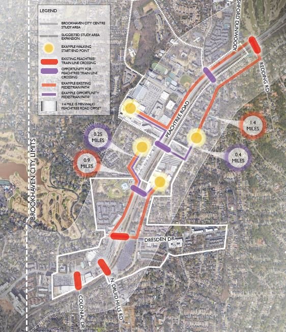
PROJECT CHALLENGE - ‘THE RIVER’
The challenge of the Peachtree Road “river” relates to travel time and transportation options for those who travel from one side of Peachtree Road to the other. Within the project study area, four roads intersect with Peachtree Road: Colonial Drive, North Druid Hills Road and Dresden Drive are all located within the same 1/3 mile segment. This leaves a 1.5 mile stretch between Dresden Drive and Redding Road with no opportunity to cross Peachtree Road.
By integrating additional options for safely and conveniently crossing Peachtree Road, a condition is created that begins to knit together the two sides of Peachtree Road and reduce the disconnect.
| Location | Broohaven, Georgia |
| Year Completed | In Progress |
| Design Team | Chris Mutter |
SIMILAR PROJECTS


